This autumn, the SDI4Apps project has developed a state-of-the-art server platform to facilitate the rapid development powering of sophisticated web GIS applications.
The platform is implemented as a virtual cloud node that for the duration of the project is hosted by the Masaryk University in Brno. However, in a post-project commercial operation scenario, the SDI4Apps platform may be hosted by any compliant cloud-data centrew providers, including but not limited to Amazon Web Services.
The platform may be used for anything from implement a standards-compliant INSPIRE geoportal — or it may be used as a basis for web GIS application — advanced or simple. That is where the SDI4Apps Open API comes into play.
Application developers who wish to build spatial applications based on the SDI4Apps platform have a wide array of open standards based protocols at their fingertips.
The Open API exposes the following public interfaces:
- Web Map Server (WMS)
- Web Feature Server (WFS)
- Web Coverage Server (WCS)
- Catalog Service (CS-W)
- Sensor Observation Service (SOS)
- Graph database query end-point (SPARQL)
The API also provides access to datasets that are already loaded into the platform such as a basemap built on Open Street Map data and more.
What makes the OpenAPI interesting, beyond building your own custom GIS server is that it is cloud-ready and can exploit the pontial of using cloud technologies to scale up and down server-side capacity to meet variations in usage.
It is also worth mentioning that the Open API provides three tools to aid users in building applications:
- LayMan — a tool to load and manage your own spatial data into the SDI4Apps cloud and publish them as WMS and WFS services
- s4a.js — a client-side JavaScript library to facilitate rapid application development and;
- HSLayers NG — a geoportal boilerplate template that forms an advanced starting point for development of custom geospatial web applications.
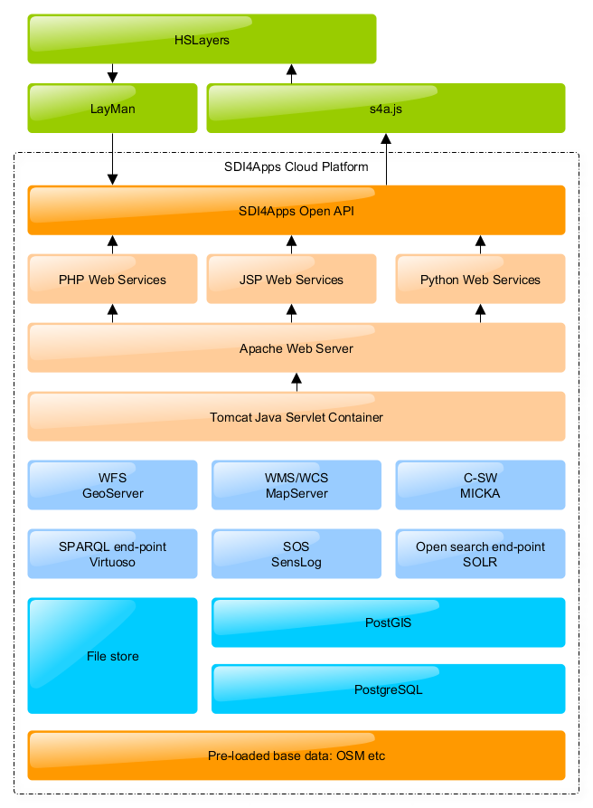
Overview of the SDI4Apps Open API


