
The workshop took place during a cold winter day of 18 January 2016 at the premises of the Czech Association for Geoinformation in Prague. The main aim of the workshop was to introduce new developments and innovations as a result of 3 currently running EU projects including SDI4Apps, OpenTransportNet and FOODIE.
Nearly 150 participants keen to hear some news from the field of open geospatial data. The audience comprised of representatives from ministries (Ministry of Interior, Ministry of Transport, Ministry of Environment), environmental agencies (Agency for Nature Conservation and Landscape Protection, Czech EnviroNmental Information Agency), academia and public administration from the whole country as well as institutions dealing with spatial planning and development (IPR of Prague, Czech Office for Surveying, Mapping and Cadastre). This event attracted a lot of attention between professionals from academia, researchers, representatives of GIS and/or IT commercial sector, data producers, remote sensing stakeholders, map makers, students and also public.
The key question was to identify the European business models for open data. A numerous open data projects are financed from the European Union’s budget. However, the end of a funded phase of a project very often means that created data are not available any more. Karel Charvát therefore opened this workshop with this question and asked the audience to start finding answers and solutions.
Other three presenters then briefly introduced datasets developed in the above mentioned projects including:
- Smart Points of Interest (SPOI) – a global dataset counting almost 24 million points of interest ordered by the Waze as well as OSM classifications; compiled from 500 different data sources, distributed in the RDF format.
- Open Land Use (OLU) – a dataset, so far, covering the Czech Republic, with the ambition to reach pan-European coverage. The OLU dataset provides land use data as detailed as possible in a unified data model. Currently, it combines data sources from Corine Land Cover, the Czech Registry of Territorial Identification, Addresses and Real Estate, Urban Atlas and the Czech Land Parcel Identification System (LPIS). Data are available for download in a vector format at administration level LAU2 (municipalities).
- Open Transport Map (OTM) – provides data from the OpenStreetMap in a way applicable for routing tasks with added information on the modeled near real time traffic intensity. Modelling of pan-European traffic intensity is the ambition for the year 2016. Data are available for download for NUTS3 areas or through OGC WMS; near future plan is to provide OGC WFS and routing API.
A business model was also described to overcome the abyss between a funded and non-funded phase of a project.
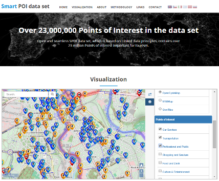
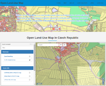

Open databases (from left): SPOI, OLU and OTM.
Based on the presentations and following discussions, it seems that datasets may be persistent after a funded phase of the projects. Harmonisation, development of so-called data pumps and establishment of periodic updates are the preconditions in this sense. Datasets will then offer added-value data and services during the non-funded phase of the projects. Such datasets should be maintained within the non-profit Plan4all association which targets at the development of a platform bridging EU organisations interested in open data.
Tomáš Řezník introduced a new platform for precision agriculture as one of the results of the EU project called Foodie. This platform integrates open and commercial data into one unified user-oriented portal to satisfy daily needs of farmers; from reference data (cadastral maps, aerial images, LPIS) through telemetry of machinery to application of fertilizers and pesticides.
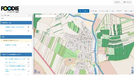
User interface of the FOODIE platform.
Karel Charvát jr. presented business and environment oriented analytical tools based on agricultural machinery fleet monitoring. Similarly to his predecessor, also he described the outputs of the FOODIE project. The red line of the presentation was dedicated to increase the economic efficiency for (proof-of-concept) farms.
The last presenter, Štěpán Kafka, closed the first session with his contribution called “Quo vadis metadata?” His slides demonstrated possibilities of linking the world of open data and INSPIRE legislation to enrich metadata of spatial data through technologies of semantic web.
The whole day was closed with round table discussions on the topic “Will we initiate the Czech public-private partnership for open data?” Such an ambitious goal has not been achieved, however, many interesting ideas were expressed:
- Participants generally agreed that opening of (geo)data in the Czech Republic belongs to one of the best in Europe. However, a way to reach 5-star rating of open data is rather still a long one.
- Several discussions dealt with an idea whether all data should be open – and if not – which data should be closed and encrypted (especially when taking into account the current security situation in Europe).
- Other debate focused on the differences between the RDF format and relational databases. Otakar Čerba quoted a colleague, Runar Bergheim from the Norwegian company Avinet, that real-world objects and their relationships can be far better expressed by a network graph than the relational model.
- Finally, the ongoing question “Will the most detailed Czech reference database – ZABAGED – be offered to users as open data?” was raised. The answer was: “maybe one day, as soon as the Czech Office for Surveying, Mapping and Cadastre will cover the expenses for data maintenance with its own profits”.
All presentations (in the Czech language) are online available here.


