
The Plan4business project (2012-2014) has identified a gap in land use data availability, especially outside big cities, in suburban and rural areas. The Urban Atlas of the European Environmental Agency covers only cities above 100,000 inhabitants. So for example in the Czech Republic, only 13 cities are covered. For the rest, there is the Corine Land Cover, which can be used only for regional and national analysis.
The lack of land use data on local level led to an idea of combining data from various sources and of different levels of detail into a seamless map. This idea has been picked up by the SDI4Apps project and turned into a pilot application (Pilot IV: Open Land Use Map through Volunteered Geographic Information). The innovative aspect of the pilot is not only in the methodology of combining data into a seamless database, but also in using crowdsourcing for data collection and update. An important aspect is that data are available as open data.
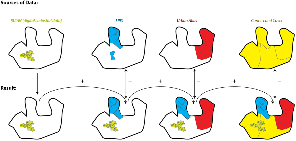
The methodology is simple:
- All available open data from a certain territory are collected and stored in a database.
- These data are harmonised into a common data model based on the INSPIRE data specifications on land use and using the same HILUCS classification.
- Data of the highest level of detail (usually not covering the entire territory) are combined with data with second highest level of detail and so on (see the figure below).
- Data are published for download and as a WMS service.
- Data are updated through crowdsourcing, either online based on remote sensing images or directly in the field through a mobile application (not yet implemented).
The aim is to cover the entire Europe and then extend it to a global dataset. The first country that is now completed is the Czech Republic where the following open data sources were used:
- Digital cadastre data (RUIAN, highest level of detail)
- Land Parcel Identification System (LPIS)
- Urban Atlas
- CORINE Land Cover
The steps undertaken for combining the data are shown in the following figure.
The Open Land Use Map in the Czech Republic can be accessed at https://sdi4apps.eu/open_land_use/. There you can find more information about the dataset and links for data download. The map can be also inserted into any HTML websites as an embedded object (iframe) as you can see below.
Th next country to be covered is Latvia. Stay tuned and follow our news through this channel.


Thanks for describing methodology
Tomas, very ambitious and congratulations, but there are only a few EU countries that make their LPIS data available to the general public … and to projects such as yours. Many more will make the data available for research purposes, but not for REUSE in the manner that you suggest. Do you think that there is a move towards making such data available with Open Access? What is the Creative Commons licence that you use for the data available from the Czech Republic (e.g. CC-BY-NC-ND?). Best wishes.
Thanks Gerry for your comment. In my opinion, opening public data for reuse as we suggest is inevitable and will happen at some point. Availability of data in the Czech Republic is quite good in this sense and we get cadastral data and LPIS data for free, they are publicly available online for download and they are in the Public Domain.
The access to data is sometimes not as straightforward. In the Czech Republic, the download of LPIS data is only for small territorial units – cadastral districts. Downloading data in this way would take a lot of work. But we asked the data provider to send us the entire database and they did, very smooth process. We haven’t tried yet in other countries, but now we are processing data in Latvia, soon in Slovakia, Belgium, Ireland and Greece.
The data of the Czech Open Land Use Map are available for reuse including commercial activities, provided that the data sources are acknowledged:
– Directorate-General Enterprise and Industry (DG-ENTR), Directorate-General for Regional Policy
– Czech Office for Surveying, Mapping and Cadastre
– Ministry of Agriculture of the Czech Republic
– SDI4Apps
Thanks again and ww will welcome any further discussion in this and any other topic. Cheers, ToMas
Hello,
Congrats for the initiative!
I would like to know if the data for Greece is now available and/or downloadable.
Thanks,
Elena
We will work on this soon, we need to have this for MedHack http://www.medhackathon.eu/. So I expect, that it will be available before end of May. Some preliminary version already exists, see here http://app.hslayers.org/ilida/ .
Thank you for your quick answer Karel ;)
You are welcome, I am sure than it will be something usefull for MedHack
Dear Gerry
The OLU of Czech Republic is something like minimalistic model based on available data. We have also some minimalistic model, which we now produce on Latvia https://sdi4apps.eu/open_land_use_lv/ an, which we are able to provide for any European countries. We expect, that most of solution will be something between.
To be possible provide easy update of OLU, database is divided on single NUTS5, so we can easy provide update on the base of available data. We are now also preparing metadata, where for every NUTS will be information about origin, it will allows download or visualize this data.
We are now interested about cooperation with different organization on building of OLU for different countries, but also on development of applications, based on OLU. So we are ready to cooperate on different hackathons, projects and other events. Nearest event will be Hackathon in Riga, information will come soon.
But we are ready to cooperate also on other events.
Karel
Many thanks, really an interesting initiative that can be adopted to other places also.
Yes, our goal is at first cover all Europe