The idea aims to stimulate further development of the one of SDI4Apps pilots dealing with “Ecosystem services evaluation”. Main ambition is to create the single web/mobile website/portal prototype tool (human readable interface) allowing to raise awareness of the relevance of biodiversity and the ecosystem services and explain the complex concepts and benefits related to the Ecosystem services evaluation in a simple way to the wider public. At the same time tool shall provide also the domain experts with the possibility to create the zonal statistics from the outcomes of the ecosystem services evaluation and share related spatial data/services, documents (eg. methodologies, or models) in connection to the work done via ESP visualisation tool, including the projects (e.g. MAES catalogue of case-studies) describing the particular implementations of ecosystem services. For machine readable interface, where possible appropriate API will be made available to strengthen the further reuse of the resources.
Wider context
EcoSystem Services (ESS) represents the direct and indirect contributions of ecosystems to the human well-being. Action 5 of the EU Biodiversity Strategy to 2020 calls Member States to map and assess the state of ecosystems and their services in their national territory. Pilot aims to provide in connection to the Mapping and Assessment of Ecosystems and their Service (MAES) activities the common interface facilitating the access and exchange of the knowledge and resources related to the topic of ESS with the possibility to visualise the ecosystem services values for particular location of the interest on national level with the potential for re-use in other countries or for links to EU level. Pilot aims to address the challenges identified during the MAES Delivery Workshop organized in Brussels on 15-16 December 2015, particularly in area of:
- strengthening and using the knowledge base on biodiversity and ecosystem services in order to contribute to halting biodiversity loss and reach the EU 2020 biodiversity target
- where possible re-use the activities and their outcomes already done via ESP-VT and DRDSI and Openness projects
End-user demand
At this moment, the main user demand comes from research and public sector domain, mainly from authorities involved into the activities related to the implementation of the Action 5 of the EU Biodiversity Strategy to 2020.
When completed by the 2020 target, the mapping and assessment of ecosystems and their services , and the valuation and accounting work will allow public decision – makers and private – sector stakeholders to better understand how our economy and society depend on healthy, resilient and productive ecosystems and to ensure that inter-dependencies between human activities and ecosystem condition are adequately taken into account in planning and decision making at all levels.
At the same time methodologies and input and output data can be of wide use also for the national and local activities driven by the non-governmental sector aiming to improve the quality of the life as well as strengthen the governance transparency via participatory approach (Open government participation OGP).
In case of Slovakia, set of possible target stakeholders have been identified during the collection of the user requirements process. They cover all main types of authorities and individuals from public sector, through private, R&D, non governmental authorities to the citizens.
Essential components:
- Content management system CMS
- User management system
- Storage for resources for spatial (vector, gridded data) and non spatial (documents, media) resources . Storage shall support relational and semantic store options
- Transformation component
- Processing/Calculation component
- Publication component
Foreseen functionality:
- User registration and maintenance
- Possibility to upload, store and maintain resources
- Transformation of the spatial data resources
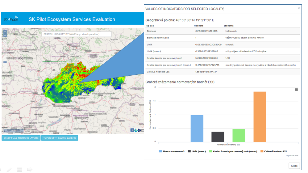
- Data processing and calculations (e.g. Zonal statistics)
- Publication of the resources (via webinterface of CMS, via web services, API)
Short methodology approach overview:
- Re-use or development of the web interface of the ESS Portal
- Design and implementation of processing functionality supporting the mapping ESS and calculating the zonal statistics as an outcomes of the ESS evaluation
- Possible use cases for the ESS projects to be provided as initial case-studies:
- ESS utilisation for the evaluation of landscape potential to provide the recreational services
- ESS in city/urban environment
Foreseen datasets to be used:
- Reference data for ecosystem mapping
- Relevant data from DRDSI catalogue
- Datasets from the initial version of ESS pilot
- Relevant data from Baltic Open (Geo) Data Hackathon 2016
- Data from LENGTH
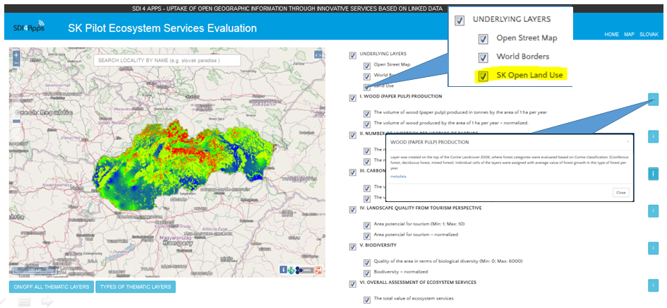
- Data from SK INSPIRE Open Land Use Map
- Selected and available national datasets from Slovakia
Foreseen software / models components:
- SDI4Apps framework/enablers
- Geonetwork / CKAN for metadata
- GeoDCAT-AP via
- OpenDataNote for data transformations
- Geoserver for publication of the data
- LD proxy: WFS2LD
Results from Baltic Hack:
- Alignment of the pilot with the SDI4Apps development and enablers
- Design adjustment (Lighter graphical user interface)
- Re-use of selected enablers (GeoServer, Post GIS)
- Enrichment of the pilot with the SK Open Land Use Map
- Support for data processing and calculations (e.g. Zonal statistics)
 Link: http://skpilot-viewer.virt.ics.muni.cz/ol3/eng/map-dev.html#
Presentation of the results: https://goo.gl/aKE6c2
Contact: martin.tuchyna@sazp.sk


Nice, it will be nice, if you will inform us about future progress.