This application “Athens Museum Planner” from authors Dmitrii Kozhuch and Raitis Berzings won the second place in MEDHackathon applications contest.” za : “This application “Athens Museum Planner” from authors Dmitri Kožuch and Raitis Bērziņš won the second place in MEDHackathon applications contest. The application can be viewed at https://sdi4apps.eu/athens_museums/ .
The geodata layers used in the application are published as WMS service and can be viewed for instance at OpenTransportNet portal: http://goo.gl/6Yu5hB .
There were some quite interesting tasks during the MEDHackathon. Due to the fact that Greece has immensely rich cultural heritage and there were representative of ministry of culture in the audience and also Open Transport Net project was one of the hackathon sponsors – we were thinking that it won’t be a bad idea to bring together these two topics – culture and transportation.
Nowadays people are travelling much more than before – and the numbers are growing. For example if we take Greece in year 2014 it had 22 million visits, in 2015 – already 25 million (http://www.telegraph.co.uk/travel/destinations/europe/greece/articles/What-crisis-Greece-expects-record-visitor-numbers-in-2016/ ). This demand makes people who create services for tourists think how to diversify and make more interesting experience of the travelers.
One of such interesting thing that is easy to think of and can be helpful in exploring Athens for tourists (even those ones, who are not ready to spend lots of money) is introducing and promoting special public transport links that drive through certain museums.
For example it can be bus route that goes through many museums. Then the museums along this route as well as the route itself can be promoted. In this and other form – this can be seen in many European capitals. Those however nowadays are more focused generally on touristic attractions rather than museums. Berlin promotes its routes 100 and 200. Here for example is some text describing through which touristic attractions and areas of the city this route runs:
http://www.visitberlin.de/en/article/experience-berlin-by-bus-100
Here is more visual description of this route:
http://www.scribblemaps.com/maps/view/berlin_bus_100_route_map/Si6_lqRN4h
Probably from the beginning this route number 100 wasn’t conceptualized as being for city visitors to see all most important attractions in Berlin, but become such with the time, as people realized that it actually passes through most important tourist attractions in Berlin.
As it was said there is similar situation in other European cities. Here is the description of 3 top sight-seeing bus routes in London:
https://www.visitbritainshop.com/world/articles/top-3-bus-routes/
In Athens so far these studies of interlinking between sights (in our case museums) and public transport routes haven’t been taken place. But there can be some potential in this. For instance, here is some question someone posted on Trip Advisor (big forum for tourists) :
(in two word the question is ‘How to do sightseeing in Athens moving just by metro lines?’, the answer of the local is to go to Ακρόπολη metro station and explore the sights in the space triangle between Ακρόπολη, Σύνταγμα and Μοναστηράκι metro stations. First step in such study of exploring relations between public transport links and museums is to mash those layers on the map. The data about public transportation system (GTFS file with public transport routes, stops, time schedules etc.) can be obtained from: http://geodata.gov.gr/dataset/oasa
The museums have been downloaded from Open Street Map project through their API.
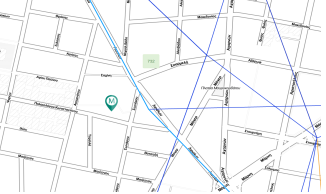
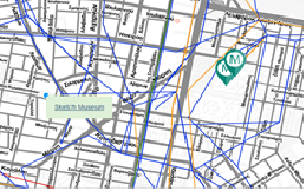
And this initial step is exactly what the application (currently found at: https://sdi4apps.eu/athens_museums/ ) does. It displays layers of public transport routes and museums. As well as this it is able to identify museums that lie in the radius of 500 meters from the stops on the route. So if I click on the certain route (in model case it will be one of the routes that goes nearby place where I stay in Athens) it will display me all museums that lie along it. Say someone is staying in Novotel hotel (intersection of Μιχαήλ Βόδα and Λιοσίων streets), then he can zoom to the location of the hotel on the map and click on some link that passes nearby. The link will get highlighted, its reference (732) will be displayed and museums along the route also.
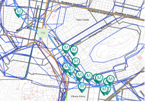
If the map gets zoomed out the rest museums on the line also will be seen:
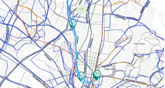
There are two routes coming near the hotel – so the visitor may want to compare on which there are more museums. He then can click on the second one. And it is the route with number Γ12 and see also all museums along the route. They are less and not so clustered.
Also it is possible to explore the information about museums on click:
Then there is redirection to the page from which the data with museums was taking, in this case Open Street Map:
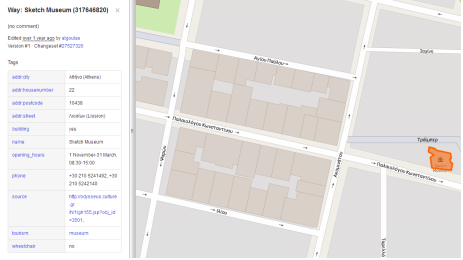
If the URL link of the museum is available – it is possible to redirect there – so the user can get to know what is the current exposition in the museum.
So this is an initial step (the work (data processing, backend services (that return museums, routes and calculate which museum lie near selected route) and frontend was done in couple of hours ) ). In the further steps it is foreseen to add filtering of museums (by themes), routes (by mode of transport), also it is possible to rank the links according to the criteria given by users or even go further than that and create public transport journey planner where user will add museums as intersteps.
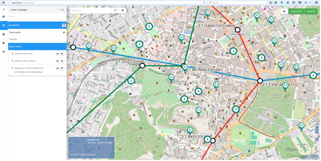
Certain spatial layers (metro lines, metro stops and museums) used in application were also published at Open Transport Net portal. If you come to http://opentnet.eu/create-maps , then go to Hub Layers and find datasource (WMS service) called ‘Athens – public transport and museums’ you can add it to the map and use in mash-ups. As well it is also accessible to use as WMS service elsewhere (in any GIS desktop).
Here how it looks: